
Maps
Maps are a visual representation of the world. Statistic Canada census maps show Canada and its geographic areas for which census data are tabulated and disseminated. This category includes static reference and thematic maps as well as the interactive mapping applications GeoSearch and Census Program Data Viewer.
What's new?

Reference maps
Reference maps illustrate the location of census standard geographic areas for which census statistical data are tabulated and disseminated. The maps display the boundaries, names and unique identifiers of standard geographic areas, as well as major physical features, such as streets, railroads, coastlines, rivers and lakes.
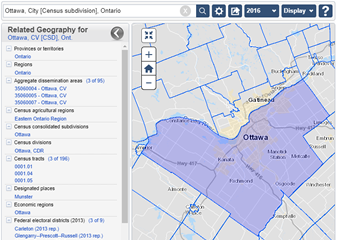
GeoSearch
GeoSearch is an interactive mapping application that makes it easy to find places in Canada, see them on a map, and get basic geographic and demographic data for them.
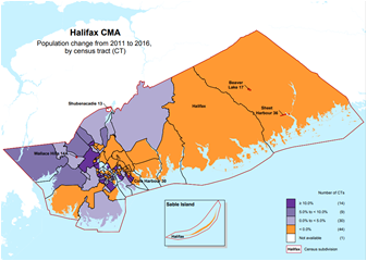
Thematic maps
A thematic map shows the spatial distribution of one or more specific data topics for standard geographic areas.

Census Program Data Viewer
The Census Program Data Viewer (CPDV) is an advanced web-based data visualization tool that helps make statistical information more interpretable by presenting key indicators in a statistical dashboard. It also enables users to easily compare indicator values and identify relationships between indicators.
- Date modified: